Erosion; Snells Beach Rd to Ariki Drive, 4th Nov 2019. SBRRA and Auckland Council Meeting notes.
Erosion; Snells Beach Rd to Ariki Drive, 4th Nov 2019, 11am
Attending; Paul Klinac Head of Specialist Delivery; Engineering & Technical Services; Infrastructure & Environmental
Michael Feather; Maintenance Delivery Co-ordinator,
James Barrat-Boyes; Programme Principal (Coastal and Slips)
Bernardo Santos; Chief Arborist, Auckland Council
Cr Greg Sayers, RLB Beth Houlbrooke,
SBRRA Chair Mark Dinniss, Deputy Chair Maurie Hooper
Notes arising from discussion. Coastal and river maintenance budget $10m pa
Nearing the end of a 14year lunar phase which has brought unusually tidal levels over the 14 year period.
The sea grass (or eel grass) is an indicator of good water quality and ecological health.
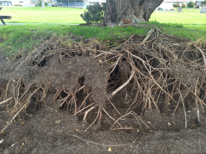
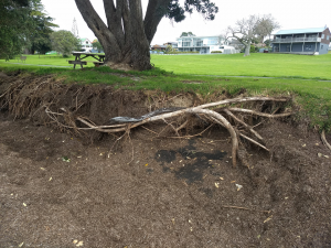
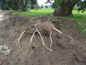
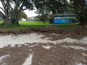
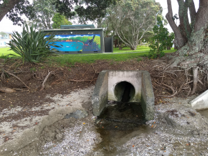
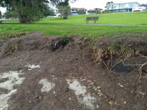
The problem identified by the public and SBRRA over recent times is the apparent rapid erosion occurring in this section of the beach, undermining of the Pohutukawa trees and threatening beachfront path and picnic tables.
In some cases, trees are sufficiently undermined to create cavities attractive for children to get into, with some danger.
Various options for handling this issue were discussed including a solid barrier, sand replenishment and natural sand movement. The removal of some sharp topped post protrusions on this section of beach, which are a hazard will take place.
It was stated that the negative influence on other parts of the beach created by a solid structure due to their influencing wave and current patterns through reflection and refraction is worse than any gain. Also walls bring about sand loss at the base of the wall creating further problems.
Manmade sand replenishment by mechanically shifting sand from one area of the beach, although less intrusive is only temporary as demonstrated by previous attempts to do this at the south end of the Sunburst Ave sea wall. Using sand bags influences wave action similar to walls and they breakdown and then cause synthetic pollution.
The arborist noted the trees were all in good health and as has been seen in several other locations, Pohutukawas are an extremely hardy tree and can survive major challenges citing cases where after being fully undermined trees have just settled on their root nest and happily continued life. These trees will have major inland root systems and they will develop even more with the seaward challenges.
All of NZs coastline will continue to recede. With the wide reserve buffer along a large part of Snells Beach and the minimal close, built environment, it was felt that any required path shift would not need to occur for 20-30years and there was no threat to the tree health for at least 2-5 years. To be monitored.
It was noted that Algies Bay required a much more engineered solution due to concerns about the inshore contour and soil type threatening major land slumping toward the sea in that area.
Further investigation of options will be made by the council team and they will report to RLB and myself.
Council staff are presently doing a lot of study and modelling, while planning mitigation proposals for more than 3000 km of Auckland Council coastline against the effects of future sea level rise coupled with increased storm activity.
Erosion; Snells Beach Rd to Ariki Drive: Meeting 3 August 2019 – SBRRA and Auckland Council . Plus further comments 4th Nov 2019. –
Beach erosion inspection August 2018


From: Matthew McNeil <Matthew.McNeil@aucklandcouncil.govt.nz>
Date: 3 August 2018 at 13:32
Subject: Snells Beach inspection
To: “moz.hooper@gmail.com” <moz.hooper@gmail.com>, Michael Feather <Michael.Feather@aucklandcouncil.govt.nz>
Hi Maurie,
Thanks for meeting Mike and myself onsite at Snells Beach.
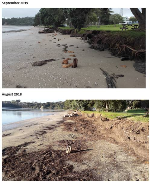
As evident onsite, sand levels on the upper beach immediately north of the Snells Beach Road boat ramp are currently low. Storm events this year that have coincided with large tides may have exacerbated this situation. This has exposed more of the reserve edge embankment, and roots of the pohutukawa trees.
Sand lost from the upper beach will have been moved offshore, but is expected to have remained within the wider Snells Beach embayment. The lowered state of the upper beach is expected on occasion, and within the dynamic envelope of natural fluctuation.
Given the wide flat intertidal area, and presence of the seagrass, it can take some time for the sand to be transported back to the upper beach in this environment.
With a significantly large reserve buffer, there is no infrastructure immediately at risk from erosion, and construction of an engineered seawall that would occupy beach space is not considered justified. The pohutukawa trees on the reserve edge appear to be in healthy condition.
Sand levels will be visually monitored, and over time it is anticipated that sand will be transported back to the upper beach by natural processes. A low berm feature was evident on the beach, as identified below. This is a sign of sand moving onshore.
Happy to keep in touch about this, and appreciate any on the ground observations you have going forward.
Regards,
Matt: Matthew McNeil | Senior Coastal Specialist, Coastal and Geotechnical Services, Engineering & Technical Services, Infrastructure & Environmental Services, Auckland Council.
From: Matthew McNeil <Matthew.McNeil@aucklandcouncil.govt.nz>
Date: Thu, Sep 19, 2019 at 2:57 PM
Subject: RE: erosion at Snells Beach
To: Mark Dinniss <chairsbrr@gmail.com>
Cc: Michael Feather <Michael.Feather@aucklandcouncil.govt.nz>, Natasha Carpenter <Natasha.Carpenter@aucklandcouncil.govt.nz>Thanks Mark for sending the photo’s through.
Looks similar to winter last year when sand levels there between the boat ramps were low. See comparison below (noting the seagrass sitting against the exposed roots in 2018). Sand levels built slowly after last winter, and looks like they have dropped again, as expected following the September storm event.
We will continue to monitor this, but nothing is at immediate risk. The picnic table is an easy relocation if need be.
Regards,
Matt